MAVLINK HUD
Attach your phone to your ELRS transmitter and instantly gain a clean, professional telemetry dashboard. Leave the laptop in the truck. Highly Portable. Total control.
NATIVE PERFORMANCE
A true native Android application. Unlike QGroundControl which uses the heavy Qt framework, we run close to the metal. This means instant startup times, superior battery life, and silky smooth 60fps rendering on mobile devices.
ELRS INTEGRATED
The perfect companion for ELRS users. Skip the complexity of setting up a Yaapu Script and dealing with limited Lua UIs. Just connect to your ELRS backpack's Wi-Fi hotspot to subscribe to MAVLink telemetry data from the flight controller, all conveniently displayed in an intuitive user interface.
AUDIO ENGINE
A comprehensive set of audio notifications for critical alerts like battery low, flight mode changes, and arming status. Stay focused on flight, not the screen.
OFFLINE MAPS
Never worry about map data again. Unlike Mission Planner, which relies on internet connectivity for maps, MAVLink HUD features an entire offline world map. After initial app setup, the map quickly loads anywhere, anytime, providing pilots with reliable navigation and points of reference regardless of internet access.
THE FIELD UTILITY GAP
Pilots have traditionally been stuck between two extremes. On one end, full desktop suites like Mission Planner and QGroundControl offer incredible depth for configuration but are clunky, heavy, and overkill for simple field flights. Carrying a laptop just to check battery voltage is impractical.
On the other end, tools like the Yaapu Script offer portability but are constrained by the limited screen real estate of a radio transmitter and the complexity of the CRSF protocol.
THE SWEET SPOT
MAVLink HUD bridges this gap. It provides a robust, easy-to-setup telemetry feedback mechanism that runs smoothly on the device you already carry. By focusing on deep optimization for ArduPilot and ELRS, we deliver a "Glass Cockpit" experience that is clean, professional, and highly portable.
SEE IT IN ACTION
MISSION CAPABILITIES
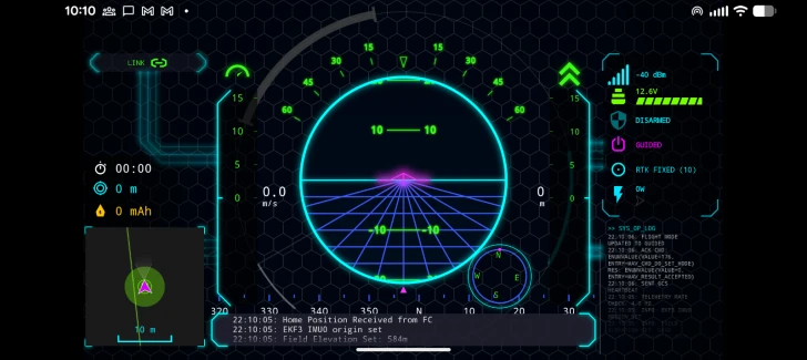
Visual Priority
Stay focused. Connection widgets fade and dim during flight to reduce clutter, while critical warnings use aggressive "Glitch" animations to demand immediate attention when needed.
Mission Statistics
Track flight duration and distance from home with precision. Our timers sync with the flight controller's internal clock, ensuring accuracy even during high-speed log replays.
Responsive Layout
Built on a strict 16:9 Safe Frame architecture. Whether you fly with an ultra-wide phone or a 4:3 tablet, your instruments remain perfectly positioned in your scan pattern.
Smart Energy Rail
Go beyond simple voltage. Our non-linear LiPo discharge curve and mAh integrator give you a visual "fuel gauge" you can actually trust to bring your bird home.
FIELD REPORTS
"Finally, a GCS that effectively uses the screen real estate on my Android tablet. The display is buttery smooth compared to the stock QGC app."
"The offline maps feature is a lifesaver. Deploying to remote zones for SAR without worrying about internet connectivity gives us huge peace of mind."
"I fly long-range FPV and the ELRS signal health dashboard is exactly what I needed. No more guessing what my RSSI actually means."
TECHNICAL SPECIFICATIONS
16:9 SAFE FRAME ARCHITECTURE
Guarantees consistent UI layout across all devices, from ultra-wide phones to 4:3 tablets. No overlapping widgets.
ARTIFICIAL HORIZON
Inside-out display with glowing neon pitch ladder, clipped horizon ring, and dynamic perspective grid.
AUDIO ENGINE
Rule-based audio alerts for battery low, flight mode changes, and arming status. Supports TTS fallback.
> INITIALIZING GRAPHICS ENGINE...
> LOADING ASSETS... [OK]
> CONNECTING TO MAVLINK STREAM... [UDP:14550]
> LINK ESTABLISHED. RATE: 50Hz
> CHECKING BATTERY STATUS... 24.5V [98%]
> GPS LOCK ACQUIRED (12 SATS)
> WARNING: GEOFENCE ACTIVE
> READY FOR FLIGHT
FREQUENTLY ASKED QUESTIONS
Does this app support DJI drones?
No. MAVLink HUD is designed exclusively for the open-source ArduPilot and PX4 ecosystems. It does not support proprietary DJI protocols.
How do the offline maps work?
The app downloads a single, quantized world map file (approx. 3GB) from our high-speed Cloudflare R2 storage. Once downloaded during the initial setup (requires internet), you will never need an internet connection for map data again, ensuring you have detailed terrain information anywhere, anytime.
What makes this better than QGroundControl?
QGroundControl is an excellent piece of software for full drone configuration and mission planning. However, for daily flying, it can be overkill and resource-heavy on mobile devices. MAVLink HUD is a native Android application designed specifically for flight. It offers a cleaner interface, faster performance, and lower battery drain when you just need telemetry in the field.